R2V RELEASE NOTES
- R2V Major New Release 7.0: Refined User Interface and Improved Performance (July, 2012)
- R2V Adds New Tools to Bring RadioMobile Image to Google Maps (Aug. 2011)
- R2V Updated to be Compatible with Windows 7 64-bit (April, 2011)
-
Enhanced "Batch Processing" and New "Boundary Trace" (Oct. 2004)
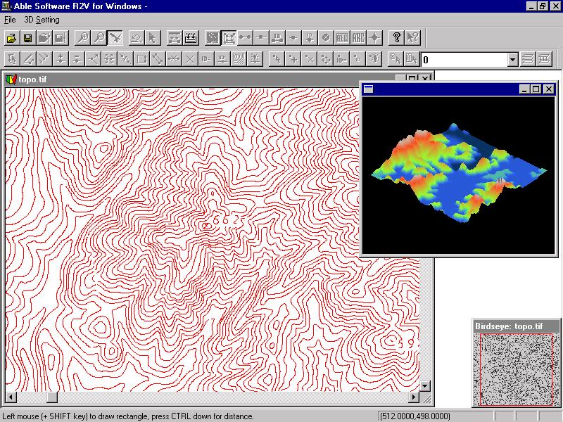
R2V Major New Release 7.0: Refined User Interface and Improved Performance
July, 2012
Able Software announced a major new release for its R2V software, an advanced raster to vector conversion software being used in more than 100 countries.
This new release includes major user interface redesign and image processing performance inprovments. The toolbars have been updated to make more identifiable and easy to understand. The bird's eye window is improved to be more responsive and uses a much bigger size to display more image details. The Menu items have been reorganized to steamline the workflow for map digitizing and raster to vector conversion software. The new release is available at no cost to R2V users who is within the 1-year support period or under support contract. Other users can contact Able Software to purchase the upgrade or sign up for the support contract.R2V Adds New Tools to Bring RadioMobile Image to Google Maps (Aug. 2011)
A new set of tools has been added to R2V to convert RadioMobile raster images to a vector format, such as ArcGIS Shapefile, geo-refenced using the KML file and loaded directly into Google Maps, Google Earth and other mapping and GIS systems.
The conversion process is fully automatic for most
images, involving only the steps of openning the image, the associated
KML file with geo-referencing information isopened automatically, performing automatic vectorization using the "Boundary Line" mode and exporting the polygons to a Shapefie. The Shapfile is geo-referenced using the information from the associated KML file.
R2V Has Been Updated to be Compatible with Windows 7 64-bit (April, 2011)
A new release of R2V is now available. This release includes:
1. The software has been made fully compatible with both the 32-bit and 64-bit version of Windows 7.
2. Vectorization algorithm is improved to perform faster with higher quality vector output.
3. Other minor improvements and bug fixes.
Version 6.5: New Functions for Editing Vector Attributes
This version includes the following new functions and
improvements:
1. "Edit/Line Attributes": use this function to edit line attributes,
including the ID values. The attributes can be exported to a database
(DBF file) in the case of shapefile. Unlimited number of fields can be
used for attributes (limited by computer capacity of course). The
attributes table can be sorted as well. The "Assign ID" option under
Line Editor has been removed since it's much easier to edit the IDs
using the Attributes function or the "Label Contours" option.
2. "Edit/Point Attributes": same as above, for points.
3. The auto vectorization process detects line width information from
the scanned map or image. The new "View/Overlay/Line Width" command can
be used to turn on the display of detected line widths.
4. A new "Vector/Select Lines by Width" function is implemented to
allow you to separate lines into a different layer by their widths.
5. The display for Line Ends has been enhanced to show the direction
with which a line was traced. It goes from a circle to an arrow. This
is useful for some data where line direction has meanings.
6. Under the "Line Editor", a new function "Reverse" is added to
reverse line direction. This option is often used together with the new
Line Ends display.
7. Added options to include line/point ID values as Z when exporting to
shapefile (3D shapefile).
8. Improved R2V online help file.
9. Please note the new project file (with attributes) is different from
the project files generated from previous versions of R2V. R2V is
backward compatible but older versions of R2V won't be able to open the
new project file.
Improved Tracing and Simpler Operations (March, 2008)
A new version of R2V is now available to R2V users with a support contract or within the one year free support period. It can be downloaded from: http://www.ablesw.com/r2v/support.html.
This new version includes the following new functions and improvements:
1. Reload Image command: this new command is used to reload the original image to undo all the changes made to the image. For example, a color image can be converted to grayscale for thresholding and auto vectorizing. After the image is vectorized, the original color image can be reloaded and used as the backdrop for vector editing.
2. New Pan Tool: this tool is used to move image around within the image window.
3. Improved Line Editor commands:
3.1 Added undo support to line tracing to continue tracing when a line is completed.
3.2 Snap to Line option. This forces the starting and ending points of a polyline to be on the closest line that is nearby when tracing.
3.3 Improved the Free Tracing Tool.
3.4 Automatic window scrolling in tracing mode. When in tracing mode, window scrolling will happen as the cursor touches the side of the window.
4. New "All On/Off" button for the Layer Define command. This button can be used to turn all layers on or off. It's convenient when you have a large number of layers to manage.
5. Improved the quality and speed of the Auto Vectorization command.
6. Other minor improvements.
Merge Multiple Map Sections into a Single Map (Sept. 2007)
9/4/2007 (Lexington, MA) - Able Software has released a new version for its automated raster to vector conversion software, R2V. New features include functions to easily merge digitized map sections into a single map. Click here to watch a tutorial video for merging maps.
R2V supports fully automatic vectorization to convert scanned maps and drawings to vector formats. Vector-based map layers can also be generated automatically from natural source images such as aerial photos and satellite imagery using the color classification and the boundary line tracing functions. Both color and black/white images stored in TIFF, GeoTIFF, JPEG, RLC, GIF, PNG or BMP formats, can be digitized automatically for center lines or boundary lines. Geo-referencing is done automatically using GeoTIFF information or through user defined control points. All geographic projections systems and conversion between them are supported. R2V exports vector data to ArcView Shapefile, Arc/Info Generate, MapInfo MIF/MID, IGES, AutoCAD DXF, SVG ( Scalable Vector Graphics) and MapGuide SDL formats.
The batch mode processing is used to digitize a large number of images using a customized script. 3D DEM (digital terrain model) can be created automatically from vectorized topo maps or XYZ point clouds and exported to USGS DEM format, as well as 3D VRML and STL formats for 3D printing applications. A color or grayscale image such as aerial photo or satellite imagery can be easily draped to the surface of a 3D DEM for 3D display and printing. R2V includes complete on-screen image and vector editing, labeling, image rubber sheeting, color image classification and separation, text symbol detection and recognition (OCR), automatic polygon layer creation, 3D terrain display and image draping. R2V is currently being used in more than 60 countries for automated map digitizing and GIS data capture applications.
This
new release is available free of charge to all licensed users by
downloading
from Able Software’s website at www.ablesw.com.
Able Software has been providing free R2V upgrades to its licensed
users since
1994.
Enhanced "Batch Processing" and New "Boundary Trace" (Oct. 2004)
A new version of R2V is now available. You can download from our website at http://www.ablesw.com/r2v/support.html. It can be installed with the password you received from us when registering your license. Please contact us if you have not registered.
This new release includes the following new functions and improvements:
- New workaround to handle some USGS DRG files that use non-standard compression method. If you had problem reading some DRG files with previous version, you should upgrade to this new version. This affects image mosaic, image merge functions as well.
- New “Boundary Trace” function under the “Line Editor”. This function automatically traces a color region. Start the Line Editor and switch to the “Boundary Trace” mode, click the left mouse button within a color, the whole region will be traced
- New “Regroup” function for “Text Blocks”. If you use the OCR functions, the new “Regroup” command will allow you to enter a distance value to regroup text blocks. You have options to regroup “All” or “Single Text Blocks”.
- New “Close Lines" function under the “Vector” menu. This function is used to create closed polygons from lines where the distance between the ends is under a user-defined threshold.New “Animation Pace” function to control the speed of 3D data display.
- Added project “AutoSave” and “Recover” functions. You don’t need to do anything to activate these options as they work in the background. The recover activates automatically if there is a software crash. This option will not replace the regular “File/Save” and frequent backup. Always save your project files and make backup copies.New functions are implemented for the batch processing, including OpenImage, ImageWarp, LoadControlPts, SaveControlPts, ExportVector, CloseImage, etc.Other minor user interface improvements and updates.
R2V New Version: Improved Image Registration (August 2004)
This new release includes the following new functions and improvements:
-
New option to flip output image vertically for the Image Warp/Registration function. This will make the image compatible with systems that use the lower left corner as the origin.
-
New option to scale the output image for the Image Warp command. You can enter a scale to adjust the output image dimension to avoid too big or too small sizes. Control points will be adjust accordingly so the absolute scale stays unchanged when the world file is created as the warping.
-
Vector data (lines and points) will also be warped during the warping process. This makes an exact fit between the vector data and the warped image.
-
Other minor user interface improvements and updates.
R2V Adds Shortcut Key Editor (March, 2004)
A new “Shortcut Keys” function is added under the Edit menu. This command allows you to customize and define shortcut keys to access all R2V commands.
This new version also includes other performance and user interface improvements.
R2V Version 5.5.0301 Released
(Jan. 2003) A new R2V update is now available to all licensed R2V users by download from our website.
This release includes the following new functions and improvements:
R2V Version 5.5.020916
A new R2V update is now available by download from our website and installed with the password you received when registering your copy. Please contact us if you need the password.
Note about using the project
file: if you
collaborate with others by sharing the project file, it is important to
make
sure everybody uses the same version of R2V. An earlier version
software may not
be compatible with a newer version project file because additional data
items
have been added.
This release includes the following new functions and improvements:
R2V Release 5.5.020304
(March, 2002) A new R2V release is now available by download
from our website and installed with the password you received when
registering
your copy. Please contact us if you need the password.
This release includes the following new functions and improvements:
- A new geo-coordinate system conversion function (Edit/Geo Coord Convert/State Plane and LL) to convert between state plane coordinate system and the lat/long system. This function supports both NAD27 and NAD83 for all states in the US. This function can convert the entire set of control points from one project system to another. It converts a single point as well.
- A new geo-coordinate system conversion function (Edit/Geo Coord Convert/UTM and LL) to convert between UTM coordinate system and the latitude/longitude system. This function supports most geodetic datum used around the world. This function can convert the control points or be applied to a single point.
- For 3D VRML export, the output file now includes color and image draping information. A 3D solid base is also added to the export so it can be used directly by a 3D printer to generate real 3D terrain model.
- A new View/Image Palette function is added so you can modify the image display palette to use different color schemes or change individual colors.
- A new Image/Conversion/Palette to RGB conversion function is implemented.
- A new Image/Conversion/Grayscale to RGB conversion function is implemented.
- Updated batch processing to support smoothing 1-bit images.
- Updated the Image/Crop Image by ROI (regions of interest) function to use the white color for background when cropping with ROI.
- Updated the RLC image import function to support certain types of RLC files.
- Display the 3D terrain model when a DEM or Grid file is created.
- A new Delete Points function has been added under the Edit Menu.
- The Image/Rotate function has been changed to use decimal number for the rotating angle. This gives more accuracy and flexibility for rotating an image.
- When open an image, the availability of a control point file or world file is checked and to be used if exists.
R2V Release 5.5.0201
(January 9, 2002) We have released a
new update for R2V (current version is 5.5.020108). This new version is
available by download
from our website and installed with the same password. Please contact
us if you need the password.
This release includes some new functions:
1. Under the Image menu, a new function, Check Angle, is implemented to
measure image skew angle for
de-skewing and image rotation.
The following steps explain how to check angles:
Step
1. Select the
Image/Check Angle command. The cursor becomes an angle cursor.
Step 2. Find a location in the image where rotation is obvious, for example, a horizontal or vertical line that is tilted.
Step 3. Click the left mouse button on the line and release it to define the anchor point. Move away from the anchor point and click the left mouse button and release to define the first line.
Step 4. When you move away from the first line, you will see a second rubber band line that will form an angle together with the first line. The second line should indicate the corrected position of the first line if the image is rotated. When the cursor is at the right location, click the left mouse button and release to confirm the second line.
Step 5. A dialog box will appear to display the angle you have
measured. The angle is in degrees and can be used for image
rotation.
2. 3D DEMs can now be exported to VRML format in addition to DXF and
XYZ formats
Once you have opened a 3D DEM/Grid file, use File/Export 3D Model
and select VRML
(WRL) format to export. The VRML file can be viewed
using a web browser (IE or Netscape) with a VRML viewer plug-in
installed. There are many free viewers available on the web for
download. Now it's time to create some of your own 3D models
and show
them on your website.
R2V Release 5.5.010
(July 20, 2001) A new release of R2V (5.5.010) is now available to current R2V users.
This new version includes:
- A new Check Control Point option under the Control Point Editor to show the residual error of a control point and the quality of its location.
- A new Pick Point option under the Control Point Editor. With this option, you can pick a point from the target image and use it as the “To/Destination” location for the source image. You no longer need to write down the coordinates.
- The triangulation algorithm has been improved to handle large numbers of control points better.
- We have fixed a control point file extension problem for saving control point files under some Windows platforms.
- Added auto use of TFW and TAB file in batch mode vectorization.
- Added BSpline smoothing command to batch script.
- Added Image/Edge Propagation to batch script.
- Added export support to IGES format.
- Other minor changes.
As
always, we thank you for using R2V and recommending it to others.
Please feel free
to contact us for any assistance.
R2V Release 5.5
(January 29, 2001) -- ABLE SOFTWARE announced a new release (Version 5.5) of R2V, its automated raster to vector conversion software for mapping and GIS data capture applications.
This new release includes the following new functions and improvements:
1. Added a Fill Area function to the Image Pixel Tool. This function can be used to change the color of connected lines, for example, parcel boundaries, to a new color and therefore avoid vectorization of non-boundary objects. See the end of this note for a tutorial on using this function.
2. New function to convert 1-bit monochrome black and white images to 8-bit grayscale. For an 8-bit grayscale image, advanced image processing functions, such as smoothing, filtering, thresholding, and noise removal can be applied.
3. In addition to the center line tracing, the boundary line tracing algorithm is improved for 1-bit monochrome images.
4. Image/Image Pixel Tool/Map Pixel Value uses a range defined by a minimum and maximum gray level value or estimates a selected region. This function can be used to easily convert a range of pixel colors to a single color for processing.
5. Fixed a bug in the tool text block group and ungroup editing.
6. The 3D DEM (digital terrain model) export is updated to be compatible with the USGS (US Geological Survey) new DEM format specification. A new algorithm for the 3D image draping function is implemented to better match a surface image to the DEM data when they are in different scales.
7. Improved handling of control points and Image World Files. Crop Image Region will automatically update control points or image world file parameters.
Tutorial for using Fill Area function to process a parcel map:
Step 1. Assume the image is a 1-bit monochrome image. Check the resolution to make sure parcel boundary lines are connected. If not, you can use Image/Resize to downsample by 2 or more factors. You can also use Image/Despeckle a few times.
Step 2. Image/Conversion/Convert to Grayscale. Note: If you don't want to change the image to grayscale, you can skip step 2 and at Step 3, define the color as the background color, and fill only lines you do not wish to vectorize. After the data is vectorized, you can save the vector lines and load the original image as the backdrop when doing editing.
Step 3. Select Image/Image Pixel Tool On, and change to Fill Area mode. Define the color as 100, or something different from the background (255) or 0 (lines). Move the cursor to a parcel line and click the left mouse button to fill. You'll see all connected parcel lines will turn to the new color. Repeat this step to fill all parcels.
Step 4. Select Image/Set Image Thresholds to adjust the threshold to include only the parcel lines (color around 100) to red and confirm this.
Step 5. Select Vector/Auto Vectorize to make sure the "Use Defined Image Thresholds" box is checked. Then start the process to vectorize only parcel boundaries.
This new release is free of charge to licensed R2V users and can be downloaded from Able Software’s website.R2V 5.0.7g
(November, 2000) In this release, we have updated the DEM export so the format is compatible with the new USGS DEM standard. More functions for 3D DEM display have also been implemented, including zoom in, zoom out, move up, down, left, right, and animation.
R2V 5.0.6i
(August 23, 2000) A new update for R2V (5.0.6i) is now available at our web site.
In this new update, we have made some improvements over existing functions and some new functions:
- A new Snap To End option under the Line Editor menu. When this mode is turned on, both the starting and ending node will snap to the end of a line that is closest to the location.
- Snap distance is now adjustable when you switch to the Snap mode.
- R2V now supports GIF image format. More formats are being added.
- Improved Form Polygon option in the Line Editor so it now can use all layers to create polygons.
- The Import Vector command under the File menu now supports multiple files.
- A Paper Space Coordinates option under the View menu. This mode uses scanning resolution for coordinates display, distance measurements, and real line thickness in zoom in mode.
- Fixed a bug that makes View/Geo-Coded Coordinates unavailable in some cases.
- Other minor improvements and fixes.
R2V 5.0.5e
(July, 2000) A new update for R2V (5.0.5e) is now available at our web site: http://www.ablesw.com/r2v/r2vsetup.exe
You can download the file to install the new version.
In this new update, we have made several improvements over existing functions and some bug fixes:
- New B-Spline based line smoothing function under the Vector menu.
- New B-Spline Smooth Line function under the Line Editor menu.
- Improved the Image/Information function that allows you to define image scanning resolution and units.
- User defined colors for line nodes and ends can now be used in addition to the line default color.
- When using File/Import Vector, R2V now checks the scale of the data and will automatically scale the data after your confirmation. The scaling factor is treated as a TFW set, so you can scale your data back to the original scale using the TFW option.
- New functions under the Edit/Text Notes Editor to move and rotate text notes.
- Fixed a bug that could set the wrong line width when exporting to DXF in some cases.
- Fixed a bug in Image/Warp for processing 24-bit color images.
- Other bug fixes.
R2V 5.0.5
(June, 2000) A new update for R2V (5.0.5) is now available at our web site:
http://www.ablesw.com/r2v/r2vsetup.exe
You can download the file and run it to install the new version. In this new update, we have made several improvements over existing functions and some new functions:
- Improved the Join Line function under the Line Editor. In the new Join Line mode, you simply drag one end of the first line to one end of the second line to join. This is much simpler than the old function.
- New Smooth Line function under Line Editor. Similar to the Vector/Smooth Lines function but works on a line by line basis.
- Image/Set Image Thresholds: It now uses two thresholds, low and high to indicate the grayscale range for vectorization and image conversion. Much more flexible for different types of grayscale images.
- Zoom in at cursor: if you don't have a selection box to zoom in, R2V will zoom in using the current cursor position as the center when you press the F2 key. More convenient when in editing mode.
- New +/- key: + to zoom in and - to zoom out, works the same as F2 and F3.
- R2V added a check for image orientation. If the image does not use the upper left as the origin, R2V will prompt you about it and adjust the orientation automatically if you want to.
R2V 5.0
(November, 1999) The new Year 2000 version, R2V 5.0, is now available to all R2V users from our web site.
Because we have made some major improvements, the project files from previous releases will not be 100% compatible with this new version. If you need to use old project file, you can simply keep the current R2V version and install the new version into a different directory and use the Vector Import and Export function to transfer vector data.
The following is a list of features and improvements implemented for this new version:
- We have lifted the pixel grid restriction of lines and points. Decimal locations are used for lines and points for better accuracy.
- New Move Line function under the Line Editor.
- New tools to draw rectangles, circles, and ellipses under the Line Editor.
- New Image/Mosaic function to create a mosaic from any number of sub images. All image types are supported.
- Image/Warp command using either Bi-Linear transform or Delauney triangulation.
- Changed the TIFF output format for 24-bit RGB image so it's more compatible with other software packages.
- Added a Snap option to the New Chain function under the Line Editor. When the "S" key is pressed, the current line will snap to the closest line.
- And other minor improvements.