marketing geological information packages...
"I am a consultant geologist with a particular interest in the geology of Southeast Asia and the South Pacific," says Dr. Graeme Wheller, President of Volcanex International Pty. Ltd. (Australia). "Early in 1995 I decided to develop and market geological information packages using ESRI's new ArcView-2 personal GIS software. The idea was to provide map-based geoscience data on disk to mineral exploration companies contemplating a move into these frontier areas."
One of the initial problems Dr. Wheller faced was how to build the polygon vector maps on which the packages were to be based, from A0-size, colored, geological maps. As a Windows user for many years, and with ArcView running happily on a Windows NT platform, Dr. Wheller wanted to avoid having to invest in UNIX-based hardware and software just to solve this problem. From watching Internet newsgroups he came across R2V for Windows and downloaded the demo software for a look.
Geological maps are among the most difficult types of maps to vectorize...
It seemed like a good approach: scan the maps and watch R2V for Windows pick out the boundaries of the different rock types automatically. Still, Dr. Wheller was a bit skeptical that it would be this easy. Geological maps are among the most difficult types of maps to vectorize, full of all sorts of topographic and geologic detail as well as numerous cultural features and text labels. How would R2V for Windows identify the correct lines?
The only way to find out was to ask. Dr. Wheller contacted Dr.Yecheng Wu, President and founder of Able Software and electronically sent him (via Internet FTP) a portion of a scanned map to experiment with. Dr. Wheller already had noticed from the demo that R2V for Windows has a neat thresholding feature which allows one to control what lines it vectorizes according to their grey levels. This feature provided a way of separating the wanted black geological boundary lines from the unwanted brown topographic contours.
R2V for Windows to the rescue ...
Dr. Wu felt that R2V for Windows could do the job with a little tweaking. But what about getting output in ArcView's shapefile format? "No problem!" said Dr. Wu, and before long he had added the shapefile format as an output option in R2V for Windows. (Up to this point, Dr. Wheller hadn't even bought the program!) Dr. Wheller still wasn't convinced that R2V for Windows could significantly reduce the time required to vectorize his complicated geological maps compared to "head-up" digitizing within ArcView. Wouldn't there still be a lot of manual editing to remove unwanted "spaghetti"? . Because Dr. Wu had been so quick to respond to his questions and to make improvements to R2V for Windows to accommodate his requirements, Dr. Wheller decided to take the plunge!
NT version of R2V for Windows makes a fast program even faster ...
With R2V for Windows installed on his NT system, Dr. Wheller got to work on the scanned maps. It didn't take long before an NT version of R2V for Windows became available ... just as well since the scans were typically more than 10 Mb in size. This made a fast program even faster! To produce arcs all one has to do is import the scanned map, adjust the threshold and press the vectorize button ... all in less than five minutes!
Admittedly, the cleaning-up process took Dr. Wheller a few hours ... thinning out nodes, labeling all the arcs he wanted to keep, adding new arcs where the linework on the original map wasn't too good, and moving nodes to make sure arcs intersected properly at junctions. Fortunately, R2V for Windows had all the necessary tools to perform these clean-up functions.
Fast solutions from Able Software ...
When Dr. Wheller needed a join arc function to add two arcs together (vital if one's maps have lots of dashed lines), Dr. Wu had it done within days. Later, after Dr. Wheller had produced a mesh of interconnected arcs which had to be converted to adjoining polygons, Dr. Wu came up with a copy arc function to deal with those arcs which are common to two polygons!
"Frankly, I was a bit surprised that Able Software would respond so quickly to my custom requirements without imposing a development char" confessed Dr. Wheller. Dr. Wu explained that Able Software is small enough as a company and that R2V for Windows is flexible enough as a product to allow for such application tailoring as long as the resultant features are ones that others could use as well.
After vectorizing 17 scanned geological maps Dr. Wheller produced the shapefile polygon map that he wanted. "Using R2V for Windows," enthuses Dr. Wheller, "I'm sure it took less than half the time it otherwise would have taken with "head-up" digitizing. I've already had one compliment from a mineral exploration company about the accuracy of the results ... better than what their own experienced draftspeople produced!"
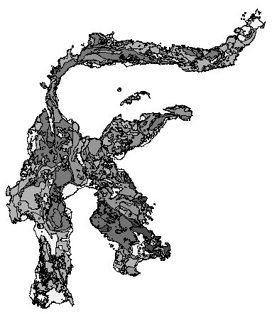
A geological map digitized by Dr. Wheller using R2V for Windows.
About Volcanex and Dr. Wheller:
Dr. Graeme Wheller is a consultant geologist with a particular interest in the geology of Southeast Asia and the South Pacific. For his Ph.D. he studied the origins of Batur caldera on Indonesia's resort island of Bali as well as other volcanoes in remote eastern Indonesia. After this he helped with research of volcanic rocks associated with actively-forming seabed mineral deposits in Papua New Guinea waters. Then, for two years until mid 1994 he worked for the Government of Fiji, in the South Pacific, helping to train local geoscientists. On return to Australia, Dr. Wheller established a geological consultancy business, Volcanex International Pty. Ltd., to provide mineral exploration companies coming into the region with research-quality and easily accessible geoscience information. For more information, contact Dr. Wheller at Volcanex International Pty Ltd, 521 Tinderbox Road, Blackmans Bay, Tasmania, 7052, Australia. Voice: (+6102)/(002) 298057; Facsimile: (+6102)/ (002) 298057; Email: volcanex@hba.trumpet.com.au; WWW URL: http://busker.trumpet.com.au/volcanex